Formed August 6, 1976 (1976-08-06)
Dissipated August 10, 1976 (1976-08-11)
Highest winds 120 mph (195 km/h) (1-minute sustained)
Lowest pressure 957 mbar (hPa; 28.26 inHg)
Fatalities 5 direct
Damage $100 million (1976 USD)
$379 million (2009 USD)
Areas affected New York, Connecticut, Massachusetts
Belle developed as a depression on August 6th, positioned just east of the northern Bahama islands. During its classification as a depression, Belle was situated approximately 250 miles northeast of Nassau in the Bahamas while the system executed a minor cyclonic loop, causing fluctuations in the weather patterns across the region. Local meteorologists closely monitored its progress, noting how its structure began to organize slowly over the warm waters of the Atlantic. Later that evening, as atmospheric conditions became more favorable, Belle was upgraded to a tropical storm and subsequently commenced a northwestward trajectory. This shift in direction raised concerns among coastal communities, prompting authorities to issue advisories and prepare for potential impacts due to the increasing intensity of the storm. In the following days, forecasters anticipated Belle could strengthen further as it moved over the Gulf Stream, fueling its development.
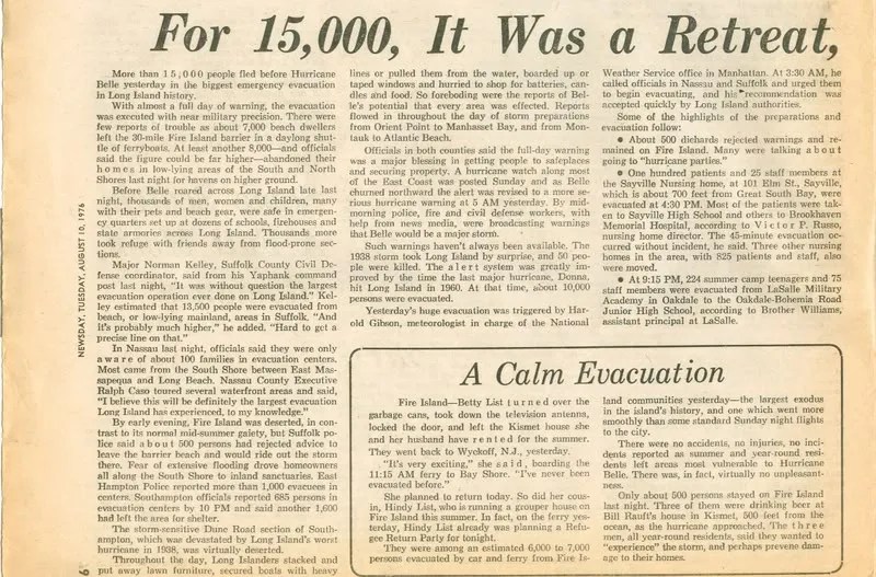
Belle escalated in intensity on the 9th, with the central minimum pressure falling to an impressive 957 mb and maximum sustained winds hitting an astonishing 120 mph, showcasing its formidable strength as a hurricane. This rapid intensification caught the attention of meteorologists and storm watchers alike, as Belle’s structure began to exhibit classic signs of a powerful tropical cyclone. However, weakening began later that day, a crucial turning point in the storm’s life cycle, and this downturn persisted into the 10th. As evening approached, the storm made landfall on the southern coast of Long Island as a category one hurricane, bringing with it heavy rains and strong winds that raged across the coastline, causing concerns about flooding and property damage as residents braced for the impact.
In the Carolinas, the highest sustained wind measured reached 37 mph at Cape Hatteras, a coastal region known for its stunning beauty and challenging weather patterns. An estimated peak gust was recorded at an astonishing 75 mph at both Frisco and Hatteras Place on the Outer Banks, reflecting the intense forces of nature that can occur in this area during storm events. Furthermore, a significant cumulative rainfall total of 3.70 inches was observed at Cape Hatteras, contributing to the lush landscapes that characterize the region. This rainfall, combined with the powerful winds, can lead to dramatic changes in the environment, affecting both the natural ecosystem and the communities that call this picturesque part of the world home. As residents and visitors alike experience these weather phenomena, they are reminded of the dynamic interplay between land and sea that defines the Carolinas.


Belle’s effects were much less than expected, in part due to its rapid motion of 30 mph (48 km/h) as it paralleled the coastline. Gusts were near hurricane force winds in some locations, though winds were fairly light in most locations from 35 to 45 mph (72 km/h). Storm surge varied from 3 ft (0.91 m) to 4½ ft. above normal.
The greatest effect from Belle was its rainfall. Four to five inches (127 mm) of rain was seen throughout New England and the Mid-Atlantic region. There was considerable small stream flooding, as well as moderate crop damage. The crop damage, combined with widespread property damage, resulted in a total loss of $100 million in damage (1976 USD, $342 million 2005 USD). In addition, Belle was responsible for 5 casualties.
The name Belle was not retired, due to lighter than expected damage and few deaths. However, due to a change in the list of hurricane names in 1979, the name Belle has not been used since.
NEWSPAPER ARTICLES




NEWSPAPER PHOTOS